Hello everyone! Due to lack of time I have not written for a long time, but it seemed appropriate to return to share with you something that for me is a great find. It is MyTourBook, a free software that allows you to import, extract, edit, view and export routes recorded with a GPS device, be it your cell phone, device for running or cycling, traditional GPS, etc. The main objective of this program is to manage your sports workouts. It can also be used to edit files generated by the GPS of your car but, as I said, it is more aimed at being able to track your workouts, visually and summarizing the results in different graphs. Like most of the competition, the program is developed in Java and is multi-platform (it includes support for GNU / Linux and Windows, not for Mac OS X).
Behold the creature in all its splendor:
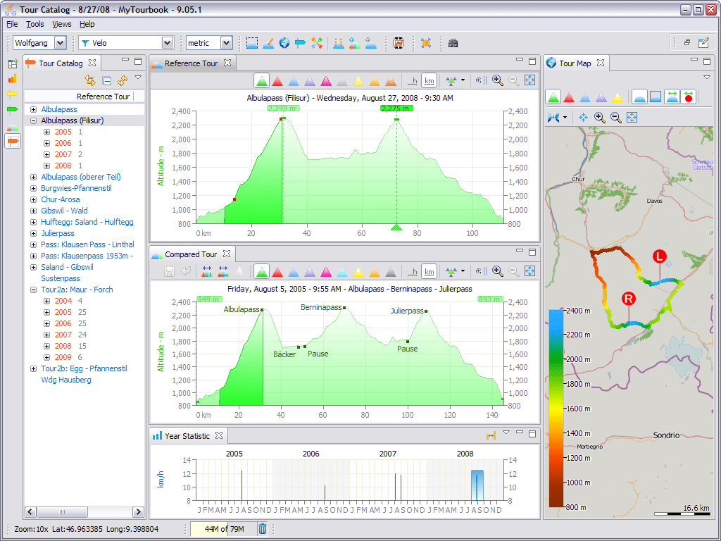
By the way, this is a screenshot that appears on the program's official page. Unfortunately I did not find any that show the program running on GNU / Linux. From here on, all screenshots are mine, using Ubuntu 15.04.
Before starting with MyTourBook
Before I move on to talking about this little gem, let me tell you how its find happened. For a few months now I have been completely dedicated to the noble task of switching entirely (or as much as possible) to free alternatives on my old Samsung Galaxy S cell phone (better known as i9000 or galaxysmtd). Something like what I did when going from Windows to Linux at the time. I think there is a point where you have to try to jump into the void and go entirely over, abandoning the use of intermediate solutions. At least that's what I wanted to try. This is not only for philosophical or ethical reasons, but also for practical reasons. My poor phone kept getting slower with every Cyanogenmod update. I tried to delete apps, I fiddled with every app I came across, made a overclock (That the CPU / GPU go faster than what they are configured from the factory). Nothing worked and I even thought that Android 4.4 was perhaps too much for my humble Galaxy S. Anyway, I tried everything. After several attempts, I decided to re-install Cyanogenmod from scratch and try F-Droid (instead of Google Play) as an application market.
I'm not going to lie to you, the transition has not been easy and it has its pros and cons. In the future I plan to write a post on this topic. For now, I can tell you that among the advantages, without a doubt, it is worth mentioning the HUGE speed jump that my phone has hit. The amount of resources that all Google applications sucked is incredible. Now that I don't use them anymore I realize it. Yes of course, I expected a little "boost", but never imagined that it was that much. Anyway, the point is that one of the applications that I had a hard time replacing with a free alternative was Adidas Micach. This application is equivalent to Endomondo, RunKeeper, etc. I basically used it to record my weekly workouts in the park with the phone. I finally found two applications that can be good replacements and that I still use today: MyTracks y Runnerup. The first was developed at the time by Google and although the source code is still available, Google has decreed that will remove it at any time. RunnerUp, on the other hand, is in good health but it was not added to the F-Droid repositories yet, so you have to install the APK package by hand.
Although both applications allow the data to be synchronized with different online services (Google Fit, etc.), since these are generally proprietary, I decided that it was better to go for a manual synchronization. That is, export the data to a file and then analyze it from my computer, without going through any cloud service. It was then that I faced the big problem of finding a program that was up to the task, that was free software and that worked under GNU / Linux. While I did find some relatively decent alternatives - like Turtle Sport or pytrainer- MyTourBook is infinitely superior. Let me show you why ...
MyTourBook
I'm not going to lie to you, MyTourBook is a complex program, with which you can do a lot of things, and it is easy to get lost among so many options and buttons. Even so, it is relatively easy to use and has a fairly intuitive interface compared to other similar programs.
The first thing that you might be tempted to do is import a GPX or TCX file, created by MyTracks, RunnerUp or practically any training program or service, since these formats are the most popular for storing this type of data.

This is what it looks like once we import the data:
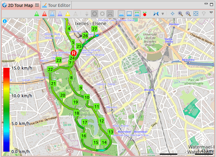
As you can see, not only does it import the file perfectly but it also indicates the different waypoints (numbers) and marks the differences in pace (pace) with different tones, according to the gradient that appears on the left. In this way it is possible to see in a very intuitive way where we ran faster or slower. This same logic can be applied to heart rate, height or speed using the different colored triangles that appear on the top bar. MyTourBook uses by default OpenStreetMap (a collaborative project to create free and editable maps), although other map providers can be selected.
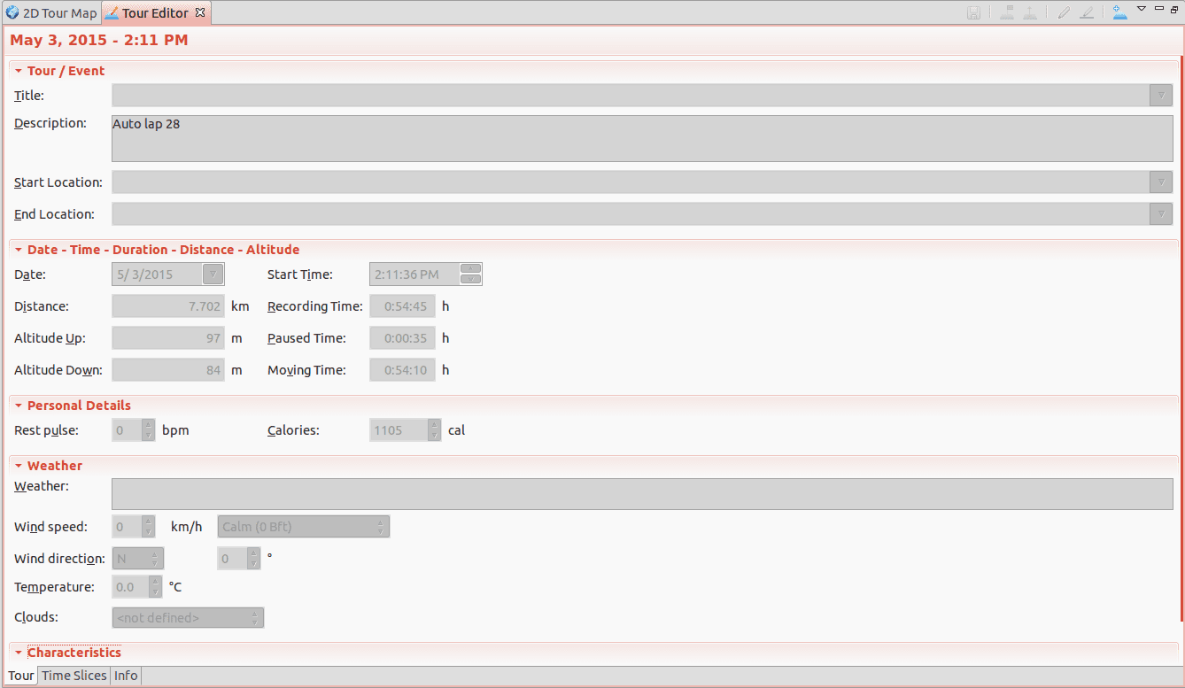
In the Tour Editor tab at the top it is possible to edit some general data of the tour: title, description, starting and ending point, date, distance, total heart rate, calories burned, weather data, etc.
Finally, under the map that we saw in the first screenshot, a dynamic graph appears that allows us to see and cross-link the route data.
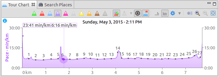
As you can see, my average pace is around 6 minutes per kilometer, which does not speak very well of my physical condition. By deduction, it would take 60 minutes (1 hour) to run the 10 K. The logic of this graph is very similar to that of the map: with the triangles at the top we can see other data, such as heart rate, speed, etc. . However, in this case it is possible to cross-link the data to taste and piacere, for example like this:
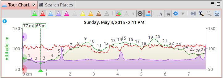
In this case, the red line is my heart rate, the green line is the altitude, and the purple line is the pace.
This system is really excellent to analyze in detail each physical activity and find possible points to improve. For example, I have a perhaps too uniform rhythm. The small purple hills that you see possibly have to do with some stop when trying to cross a street or something like that. Other than that, my pace is very static, which is not bad for some workouts (for example, recovering from a recent very strenuous activity), but not all, as is demonstrated that even running does not burn as many calories as the small successive bursts of force interspersed with moments of rest.
But, MyTourBook allows much more than just analyzing a tour in isolation. As its name suggests, it allows us to keep a record of all our tours in one place. Something like a journal or book to store all of them. Below you can see my "tour book", with some of the tours that I uploaded to the program.

The same information can also be displayed in the form of a calendar:
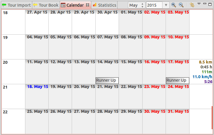
As you can see, MyTourBook shows that last week I went for a run twice. On the right, it indicates the number of kilometers traveled, the time, the pace and other data, added per week.
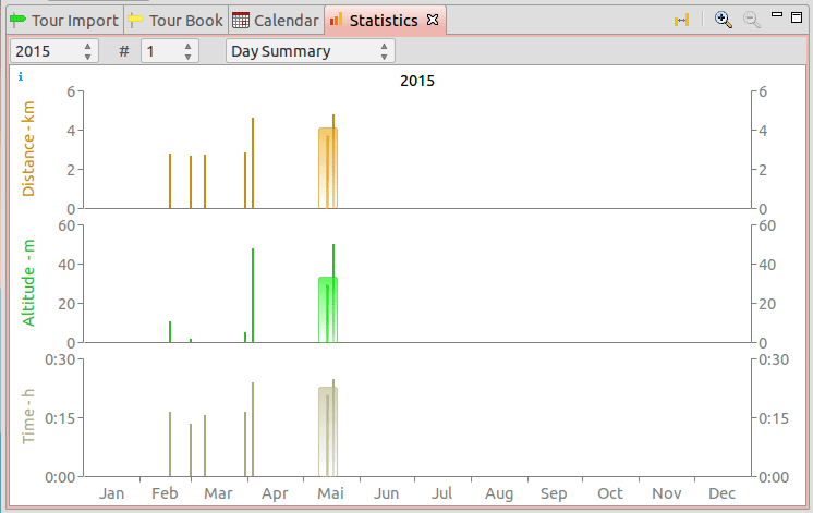
Finally, it is possible to see general statistics of our routes and filter the data by day, week, month or year, which allows us to have a fairly precise control of our training:
In general terms, we have covered the most important functionalities of the program. However, do not believe that MyTourBook is nothing more than what is shown in this article. Believe me, you can do many other things with it. For example, it is possible to export all tours to GPX, TCX or CSV; import data from serial port; compare tours with each other; make a Conconi test; incorporate photos of your tours; or adjust the altitude of your tour using data provided by NASA. No, I'm not kidding ... and this turned out to be a super useful feature because my phone calculates altitude based on GPS data, which in itself they are not 100% reliable. On the other hand, MyTracks has some trouble recording altitude well. Thanks to MyTourBook this is no longer a problem.
Anyway, it would be too cumbersome to tell you everything that can be done with this wonderful program. If you are a sports fan, like to go running or ride a bike and use a device to track your training, do not hesitate to try MyTourBook.
Installation of MyTourBook
1. MyTourBook requires Java 7 or higher.
En Debian / Ubuntu and derivatives that is achieved through the following command:
sudo apt-get install openjdk-7-jre
2. Then you have to download the file mytourbook_x.xxlinux.gtk.x86.zip and unzip it.
3. The mytourbook file must have execute permissions. In case you don't have them, we can assign them to you with the command:
sudo chmod + x mytourbook
Our friends users of Arch Linux and derivatives have an easier life. MyTourBook is available at AUR repositories.
To run MyTourBook in Spanish, just use the "nl -es" parameters as follows:
./mytourbook -nl is
Otherwise, MyTourBook will run using the default language of the operating system.
That's all folks. I hope you enjoy. Don't forget to leave your comments once you've tried it.
Great, I'll keep that in mind for when I start mailing again hahaha. The bad, written in Java .. I hate Java .. 🙁
Me too, but I have to admit that this program has a really beautiful interface and is quite fast. It doesn't look like Java… haha.
I imagine you use a tape to measure the pulsations, can you tell me if they all work with this type of program ???
I have always wanted to buy one but I have had the fear of this ...
Is it me or is it 100% gtk ???
@ianpocks: yes, in principle they should all work. Some devices can be connected directly with this program. Others, on the other hand, you can synchronize them with the cloud service used by these devices and then "export" the results to a GPX or TCX file, which you can import into this program. That's what I do with the Adidas tape.
Hug! Paul.
For these types of applications it is worth activating the data plan and the GPS of my Galaxy Mini. I would use the program more for my trips between city and city (unfortunately, in Lima, public transport is a pandemonium, and getting to a certain place turns out to be a nuisance if you do not know the fast routes).
but no data plan necessary
Very good! It helps me a lot now that I have a watch that comes with GPS in my sights, for my training on foot and by bike.
Thanks for sharing ;)..
Good for you, but is there a GPS watch that uses fiwmware and / or free software?
There's the leikr, created by ex-Nokia engineers
http://www.leikr.com/
To run? How did you compile that?
$ cd run
$ make
$ sudo make install
$ cd run
$ ./ run
$ make
$ Make install
Haha ... Get out of the chair, bum! 🙂
Hug! Paul.
Hi all!
This program was something I was looking for for a long time, I have installed it and entered my data but I am not able to find the RUNTASTIC files on the mobile to import them. Does anyone know where they are?
Thank you
Hello, I already achieved it by exporting the activity from the runtastic website.
Good
I can't import kmz maps. Do you know what I can do?
Thank you
You can change the format with this online application:
http://www.gpsvisualizer.com/convert_input
I have tried the RunnerUp app for android, and I have not found a way to export GPX or TCX files, however I discovered that from this application you can export the routes for other mobile applications that do use mobile data such as Strava (In my case I use it for my bike tours). Runner Up is a good alternative for those who do not want to spend money on mobile data, you can take the data without spending money and later upload it to your Strava account with a Wi-Fi connection. Soon I will test Mytracks on android to import the data to My Tour Book. Excellent contribution!
Indeed, the My Tracks app does allow exporting TCX files, now I can import my tours to My Book Tour.
Hi, I can't install it. Can anybody help me?
When I put in the terminal:
./mytourbook -nl is
It appears to me:
bash: ./mytourbook: can't run binary file: Wrong executable format
Thank you very much